T’aqrachullo Cusco: Complete Guide to Visiting the Inca Citadel of Espinar
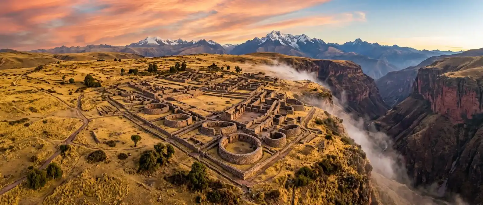
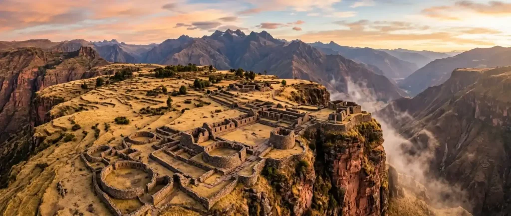
T’aqrachullo is one of the most important archaeological discoveries in Peru in recent years. Located in the district of Suyckutambo, province of Espinar, Cusco region, this Inca citadel officially opened to tourism in December 2024 after years of restoration work. With more than 300 restored structures, breathtaking views of the Apurímac Canyon, and a silence still untouched by mass tourism, T’aqrachullo represents exactly what many travelers seek: authentic heritage, stunning Andean landscapes, and the feeling of arriving before the crowds.
This guide brings together everything you need to plan your visit: what to see, how to get there from Cusco, Arequipa, or Puno, opening hours, entrance fees, climate, and recommended equipment.
What is T’aqrachullo and Why is it Important?
T’aqrachullo is a vast pre-Hispanic settlement located within the Tres Cañones Regional Conservation Area, more than 4,000 meters above sea level. The site combines Inca architecture with evidence of earlier occupations — including Wari and Qolla cultures — making it a first-class cultural palimpsest.
The complex includes more than 600 identified structures, over 300 of which have been restored for visitors. Its circular and rectangular buildings, chullpas (funerary towers), ceremonial water mirrors, and a section of the Qhapaq Ñan (the Great Inca Road) position it as one of the most complex and best-preserved archaeological sites in southern Peru.
The importance of the site also lies in the discoveries made during excavations: gold artifacts, ritual textiles, and evidence of continuous ceremonial use, reinforcing its role as a religious and administrative center within the Inca Empire.
What to See in T’aqrachullo: Main Attractions
The tour through T’aqrachullo is organized into sectors with different functions. Spending at least half a day is enough to cover the entire site, although travelers who wish to explore more slowly can easily spend a full day here.
The Viewpoint and the Three Canyons
The highest point of the complex offers panoramic views of the Virginniyoc Canyon, the Apurímac River, and the Totorani gorge. It is one of the most impressive moments of the visit and one of the few places where visitors can truly appreciate the scale of Espinar’s high Andean landscape. The dramatic cliffs and deep valleys perfectly complement the monumentality of the ruins.
The Inca Road — Qhapaq Ñan
A section of the ancient Andean road system crosses the western side of the complex. This route connected T’aqrachullo with the Three Canyons and extended toward Arequipa and the Collasuyo region, providing direct evidence of the site’s strategic importance within the Inca communication network. Walking along this path is one of the most evocative experiences of the journey.
The Chullpas and Funerary Structures
The circular and rectangular funerary towers are among the site’s most distinctive features. Their presence reinforces the ceremonial and symbolic significance of T’aqrachullo beyond its residential function. Some structures still preserve remarkably tall walls, allowing visitors to appreciate original Inca construction techniques.
The Kallanka
A rectangular structure located in the lower section of the site and connected to the Qhapaq Ñan. It is believed to have functioned as a communal or resting space associated with the movement of people within the settlement. Its dimensions and strategic location suggest ceremonial or administrative use.
Yuractorriyoc — The Water Mirrors
One of the most unique sectors of the archaeological complex. It contains ceremonial water pools carved into the rock, used for both water storage and astronomical observation. Archaeologists also documented burials and a Qolla-style monolith used in rituals, reinforcing the sacred character of this area.
The Houses and Corrals
Scattered throughout the site, the circular and rectangular residential structures preserve remarkable domestic elements such as hearths, stone seats, and grinding stones that help visitors imagine the daily lives of ancient inhabitants. The corrals, measuring approximately 28 meters long and 18 meters wide, were used to shelter Andean camelids, one of the economic foundations of the Inca Empire.
Pukara Qèpa
A sector located in the upper part of the complex featuring funerary enclosures and structures that document the overlap of Wari and Inca occupations within the same space. It is the area that best illustrates the historical continuity of the site over centuries of use.
How to Get to T’aqrachullo
T’aqrachullo is not an easy-access destination, and that is part of its appeal. The trip requires prior planning, especially for the final dirt-road section. Below are the main routes from nearby cities.
From Cusco
This is the most common route. The journey covers 244 kilometers along the Cusco–Espinar highway and takes approximately 5 hours to reach Yauri (capital of Espinar). From there, travelers continue on a dirt road toward Suyckutambo (an additional 45 minutes). The route then continues to kilometer 29, where the Totorani Bridge marks the official entrance to the archaeological site.
- Total distance: 244 km + 45 minutes on dirt road
- Estimated travel time: 5 h 45 min
- Recommendation: four-wheel-drive vehicle for the dirt-road section
From Arequipa
Take route PE-34A to Juliaca, then detour at Patahuasi toward Colca Canyon, passing through Chivay, Callalli, and Sibayo before reaching Suyckutambo. This route can easily be combined with a visit to Colca Canyon.
From Puno
Travel via route PE-34A through Juliaca, Santa Lucía, Lagunillas, Imata, Negromayo, Héctor Tejada, Yauri, and Suyckutambo. This is an excellent option for travelers exploring the Altiplano region.
From Apurímac
Take route PE-3Sw from Chalhuahuacho to Abra Acopunco, continuing through Santo Tomás, Velille, and Coporaque to Suyckutambo. Less traveled but entirely feasible with an appropriate vehicle.
Opening Hours, Entrance Fees, and Access
T’aqrachullo currently operates on a reference schedule from 8:00 a.m. to 4:00 p.m. Entrance is free of charge according to the official tourism record. However, since the site was only recently opened to tourism, access conditions may vary depending on maintenance or weather conditions. Travelers are advised to confirm current access information before visiting with:
- Decentralized Directorate of Culture of Cusco
- District Municipality of Suyckutambo
The site is still in the early stages of tourism development, meaning services such as bathrooms, cafeterias, and complete signage are still limited.
Climate and Best Time to Visit
T’aqrachullo is located above 4,000 meters in the high Andean puna ecosystem. The climate is cold and dry for most of the year, with average temperatures between 7.2 °C and 8.6 °C.
- Best season: April to November (dry season, clear skies, minimal rainfall)
- July and August: nighttime frosts and strong winds are common — extra warm clothing is recommended
- Rainy season (December to March): dirt roads may become impassable
Sunrise at the site, with the first sunlight illuminating the stone structures and canyon landscape, is one of the most unforgettable visual experiences in Andean archaeology.
What to Bring for the Visit
Due to the altitude, remoteness, and lack of services, proper equipment is essential. This checklist covers the basics:
- Comfortable backpack with lumbar support
- Waterproof jacket or windbreaker
- Light and heavy gloves for temperature changes
- High-SPF sunscreen and UV-protection sunglasses
- Basic first aid kit with altitude sickness medication
- Enough water and energy snacks
- Trekking poles for uneven terrain
- Broken-in trekking shoes — avoid wearing brand-new footwear
- Phone with fully charged battery and portable charger
- Cash in Peruvian soles — there are no ATMs nearby
Nearby Archaeological Sites
Travelers with more time in the Espinar area can enrich their journey by visiting other important heritage sites near T’aqrachullo:
- Maukallaqta: another important Inca settlement in Espinar province
- Muyuqhawa: declared Cultural Heritage of the Nation in 2024
- Ayapukara and Paris Pukara: defensive sites with exceptional panoramic views
- Devil’s Throat (Laqoyoq): dramatic natural rock formation within the Three Canyons area
Combining T’aqrachullo with these nearby sites creates a two-day archaeological circuit unlike any other in southern Peru.
Frequently Asked Questions About T’aqrachullo
How much does it cost to enter T’aqrachullo?
According to official tourism records, entrance is free of charge. Travelers should confirm this information before visiting, as conditions may change depending on the season or site maintenance.
How do you get to T’aqrachullo from Cusco?
The trip covers 244 km along the Cusco–Espinar highway, approximately 5 hours to Yauri, followed by 45 additional minutes on a dirt road to Suyckutambo and kilometer 29, where the Totorani Bridge is located.
Can you get there by public transportation?
Buses travel from Cusco to Yauri (Espinar’s capital). However, the final section from Suyckutambo to the archaeological site requires private transportation or local transport arrangements.
What is the best time to visit T’aqrachullo?
The best season is between April and November during the dry season. July and August can be extremely cold, while the rainy season may make roads inaccessible.
Are guides available at the site?
Tourism infrastructure is still developing. It is recommended to hire a local guide in Yauri or Cusco, or coordinate with specialized archaeological tour operators.
How much time is needed to explore T’aqrachullo?
A complete visit takes between 3 and 5 hours. Travelers planning to explore nearby sites or enjoy sunrise are encouraged to stay overnight in Yauri or Suyckutambo.
Conclusion: A Destination That Still Feels Like a Discovery
T’aqrachullo offers something very few archaeological sites can still provide in 2025: authenticity untouched by mass tourism.
Reaching T’aqrachullo requires planning, the right vehicle, and a willingness to travel beyond Peru’s classic tourist circuits. In return, visitors experience more than 300 restored structures, jaw-dropping views of the Apurímac Canyon, a living section of the Qhapaq Ñan, and the silence that only exists before mass tourism arrives.
That moment — when a site is extraordinary yet still peaceful — never lasts forever. T’aqrachullo is living that moment right now.