Tree Canyons Cusco Guide: Peru’s Hidden Canyon
Peru is a country of extraordinary landscapes — from the Amazon basin to the Atacama desert, from glaciated peaks to Pacific coastline. Yet even among such abundance, there are places that remain hidden from the mainstream tourist trail, known only to those willing to venture beyond the well-worn paths. The Tree Canyons in Cusco is one of those places. A dramatic canyon landscape tucked away in the Espinar province of the Cusco region, this geological wonder offers travelers something increasingly rare: raw, unfiltered Andean wilderness with almost no crowds. This guide covers everything you need to know before you go.
Table of Contents
What are the Three Canyons?
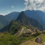
The Tree Canyons — literally “Three Canyons” in Spanish — is a spectacular natural formation located in the Espinar province of the Cusco region, in the southern highlands of Peru. The site takes its name from three dramatic canyon gorges that converge in a single area, carved over millions of years by the relentless force of Andean rivers cutting through ancient rock formations.
Unlike the Colca Canyon near Arequipa or the Cotahuasi Canyon — both well-established on Peru’s tourist circuit — the Tree Canyons Cusco remains largely off the radar for international visitors. There are no large hotels, no organized tourist buses, and no souvenir stalls lining the viewpoints. What you will find instead is something far more valuable: an untouched Andean landscape where the only sounds are the wind, the river far below, and the occasional call of a condor circling overhead.
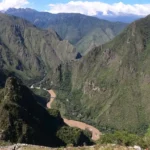
The canyons sit at elevations ranging from approximately 3,800 to over 4,500 meters above sea level, placing them squarely in the high-altitude puna ecosystem. The combination of extreme altitude, dramatic topography, and the convergence of multiple river systems creates a landscape of extraordinary visual power — sheer cliff faces dropping hundreds of meters, terraced hillsides shaped by centuries of Andean agriculture, and river valleys of brilliant green cutting through the rust-colored rock.
Did You Know?
The Tree Canyons area sits within the Espinar province — one of the least-visited parts of the entire Cusco region, yet home to some of its most dramatic hidden landscapes in Peru.
Geography and Landscape
To understand what makes the Tree Canyons Cusco so visually striking, it helps to understand the geological forces that shaped it. The Cusco region sits on a complex zone of tectonic activity where the Nazca Plate pushes against the South American Plate, driving the ongoing uplift of the Andes mountains. Over millions of years, this uplift has created some of the most dramatic relief on Earth — and the rivers that drain the highlands have responded by cutting ever deeper into the rising rock.
The three canyons that give the site its name were carved primarily by tributaries of the Apurímac River system, one of the most powerful river systems in the Andes. The Apurímac — whose name in Quechua means “the great speaker” or “lord who speaks” — is considered by many geographers to be the most distant source of the Amazon River itself, making the waters that flow through these canyons part of one of the greatest river journeys on the planet.
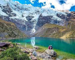
The landscape at Tree Canyons displays a remarkable layering of color and texture. The canyon walls expose different geological strata — bands of red sandstone, grey limestone, and dark volcanic rock — that read like pages of Earth’s history compressed into a single vertical face. At the canyon floors, rivers run turquoise and green, fed by snowmelt from the high peaks above and rich in minerals dissolved from the surrounding rock.
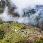
The surrounding plateau terrain is classic Andean puna: vast, treeless grasslands stretching to the horizon, punctuated by rocky outcrops, high-altitude wetlands called bofedales, and the occasional dramatic quebrada — a steep-sided ravine — that suddenly opens into a canyon of breathtaking depth. The scale of the landscape is genuinely humbling, with a quality of space and silence that is rare anywhere in the modern world.
Among the most remarkable geological features of the canyons in Peru is the way the three gorges converge, creating natural viewpoints where visitors can look simultaneously into multiple canyon systems. On a clear day — and there are many in the dry season — the visibility stretches for dozens of kilometers, with snow-capped peaks visible on the horizon and condors riding the thermal currents far below the viewpoint rim.
T’aqrachullo Connection
No guide to the Tree Canyons Cusco would be complete without discussing its deep connection to the T’aqrachullo trekking route — one of the most extraordinary and least-known multi-day treks in the entire Cusco region.
T’aqrachullo is an ancient Andean landscape located in the high puna of the Espinar province, characterized by dramatically eroded rock formations, original Inca road sections, and a profound sense of remoteness that has largely disappeared from the more popular trekking routes of the region. The name itself comes from Quechua and refers to the distinctive rock formations that define the landscape — towers, pinnacles, and sculpted outcrops shaped by millennia of wind, rain, and frost.
The T’aqrachullo trek passes through territory that directly overlooks and connects with the Tree Canyons system. As trekkers move through the high puna, the route reveals dramatic canyon viewpoints where the full scale of the gorge system becomes visible — a perspective that is simply impossible to appreciate from the road. The combination of the T’aqrachullo rock formations and the Tree Canyons landscape creates one of the most visually diverse trekking experiences available anywhere in the Cusco region.
What makes this connection particularly significant from a historical perspective is the presence of original Inca road sections along the T’aqrachullo route. These stone-paved paths — part of the greater Qhapaq Ñan network — were used by Inca administrators, soldiers, and traders to cross the high puna between Cusco and the territories to the south and west. Walking these sections today, with the canyons visible in the distance and the silence of the puna all around, is an experience of rare historical depth.
For visitors interested in combining the canyon landscape with a genuine trekking adventure, the T’aqrachullo route offers the ideal entry point. Unlike the Tree Canyons viewpoints, which can in theory be reached by road, the T’aqrachullo trek requires commitment — several days of walking through high-altitude terrain with overnight camping — but rewards that commitment with access to landscapes and perspectives that no road can reach. Explore our adventure tours in Peru for full itinerary details.
Wildlife and Nature
The Espinar province and the Tree Canyons area support a remarkable diversity of Andean wildlife, much of it rarely encountered by tourists. The combination of canyon ecosystems, high puna grasslands, and river valleys creates a mosaic of habitats that supports species found nowhere else on Earth.
The most iconic resident of the canyon ecosystem is undoubtedly the Andean condor (Vultur gryphus), the largest flying bird in the Western Hemisphere with a wingspan that can exceed three meters. The thermal currents generated by the deep canyon walls are ideal for condor flight, and sightings at Tree Canyons are relatively common, particularly in the morning hours when the air begins to warm. Watching a condor ride the canyon thermals at eye level — or even below you, if you are standing at a rim viewpoint — is one of the most memorable wildlife experiences the Andes can offer.
Other notable bird species in the area include:
- Andean eagle (Geranoaetus melanoleucus) — a powerful raptor that hunts over the puna grasslands
- Torrent duck (Merganetta armata) — a specialist of fast-flowing Andean rivers, often spotted on the canyon floor streams
- Puna ibis (Plegadis ridgwayi) — frequently seen probing the high-altitude wetlands near the canyon rims
- Giant hummingbird (Patagona gigas) — the world’s largest hummingbird, surprisingly common in the rocky puna habitats
Mammal wildlife in the area includes the vicuña (Vicugna vicugna), a wild relative of the llama that was sacred to the Incas and whose fiber remains among the finest natural textiles in the world. Vicuña herds are frequently seen grazing on the puna grasslands surrounding the canyons, often in groups of ten to thirty animals. The area also supports populations of puma (Puma concolor), though sightings are rare, and the Andean fox (Lycalopex culpaeus), which is considerably more commonly encountered, particularly at dawn and dusk.
The bofedales — high-altitude peat wetlands fed by glacial meltwater — that dot the puna around the canyons are particularly rich in wildlife. These ecosystems act as water towers for the entire region, slowly releasing water through the dry season, and support populations of Andean waterfowl, amphibians, and the remarkable Andean cat (Leopardus jacobita), one of the rarest and least-studied felids in South America.
Best Time to Visit
Choosing the right time to visit the Tree Canyons Cusco can make an enormous difference to your experience. Like most of the Cusco region, the Espinar province has two clearly defined seasons — a dry season and a wet season — each with its own character and appeal.
Dry Season: May to October
The dry season is generally considered the best time to visit for most travelers. Clear skies, stable weather, and excellent visibility make this the ideal period for canyon viewpoints and trekking. Temperatures during the day can be pleasantly warm at the canyon rims (15–20°C), though nights drop sharply and temperatures below freezing are common above 4,000 meters, so warm sleeping gear is essential.
The months of June, July, and August represent the peak of the dry season and offer the most reliable weather. The air is exceptionally clear — a product of the low humidity — and on calm days the views from the canyon rims extend for extraordinary distances. This is also the best period for condor sightings, as the birds are more active and visible in good weather.
Shoulder Season: April and November
April and November sit at the transition between seasons and can offer an interesting combination of lush green landscapes (a legacy of the wet season rains) and increasingly stable weather. The puna grasslands are at their most vivid green in April, and the contrast between the emerald plateau and the deep rust-red canyon walls is particularly striking. These months also tend to have fewer visitors than the peak dry season months.
Wet Season: November to March
The wet season brings daily afternoon rains to the Espinar province, often heavy and accompanied by electrical storms. This makes trekking and canyon exploration more challenging and potentially dangerous, particularly on exposed ridgelines and canyon rims. However, the wet season also transforms the landscape — waterfalls appear on canyon walls that are dry for the rest of the year, the puna turns a vivid green, and wildflowers bloom across the grasslands. Experienced trekkers willing to manage the weather will find a dramatically different but equally beautiful version of the landscape.
| Month | Weather | Trekking | Wildlife |
|---|---|---|---|
| May – Oct | Dry, clear, cold nights | ⭐⭐⭐⭐⭐ Excellent | ⭐⭐⭐⭐⭐ Excellent |
| Apr / Nov | Transitional, some rain | ⭐⭐⭐⭐ Good | ⭐⭐⭐⭐ Good |
| Dec – Mar | Wet, afternoon storms | ⭐⭐ Challenging | ⭐⭐⭐ Moderate |
Travel Tips
Visiting the Tree Canyons Cusco requires more preparation than a typical Cusco day trip. The area is remote, infrastructure is limited, and the high altitude demands respect. Here is everything you need to know to make your visit safe, comfortable, and unforgettable.
Getting There
The Espinar province is located approximately 4–5 hours from Cusco city by road. The most common route heads south through the Cusco highlands toward the town of Espinar (also known as Yauri), the provincial capital and the main base for exploring the area. From Espinar, local transport or a hired vehicle can reach the canyon viewpoints. The roads in the area range from paved highways to dirt tracks that require a 4×4 vehicle, particularly after rain.
The most convenient and recommended way to visit is as part of an organized tour from Cusco. A knowledgeable local guide not only handles logistics and transport but also provides the historical and ecological context that transforms a landscape visit into a genuinely enriching experience. Browse our adventure tours from Cusco for guided options that include the Tree Canyons and T’aqrachullo areas.
Altitude and Acclimatization
The Tree Canyons area sits between 3,800 and 4,500 meters above sea level. Altitude sickness (soroche) is a real risk for visitors who have not had time to acclimatize. Spend at least two full days in Cusco (3,400m) before traveling to the Espinar province, stay well hydrated, avoid alcohol on your first days at altitude, and consider consulting a doctor about altitude medication if you have had problems in the past.
What to Pack
🎒 Essential Packing List
- Layered clothing — temperatures can swing 20°C+ between midday and midnight
- Waterproof jacket — essential even in dry season for afternoon wind and occasional cloud
- Sturdy hiking boots — the canyon rim terrain is rocky and uneven
- Sun protection — UV radiation at 4,000+ meters is intense; SPF 50+ sunscreen, sunglasses, and a hat are essential
- Plenty of water — at least 2–3 liters per day; dehydration accelerates altitude sickness
- Snacks and energy food — there are no restaurants or shops near the canyon viewpoints
- Camera with extra batteries — cold temperatures drain batteries quickly at high altitude
- Cash — there are no ATMs in the remote Espinar highlands
Responsible Tourism
The Tree Canyons area is largely untouched precisely because it sees so few visitors. Help keep it that way by practicing leave-no-trace principles: carry out all waste, stay on established paths near canyon edges, and respect the local communities and their land. The canyon rims can be genuinely dangerous — there are no safety barriers, and the drop is vertical and severe. Never approach the edge alone, and exercise extreme caution in windy conditions or when the ground is wet.
The communities of the Espinar province have a deep and ancient relationship with this landscape. If you interact with local people, do so with respect and cultural sensitivity. Ask before photographing individuals, support local guides and services where possible, and remember that you are a guest in a landscape that has been home to Andean communities for thousands of years.
Explore the Hidden Andes
Ready to Discover Peru’s Hidden Canyon Landscape?
Join our expert-guided T’aqrachullo and Tree Canyons adventures — small groups, local guides, and landscapes that will stay with you forever.