How to Get to T’aqrachullo from Cusco, Arequipa, and Puno: Complete Access Guide
T’aqrachullo is not a destination you stumble upon by accident. Located in the district of Suyckutambo, in the province of Espinar, at more than 4,000 meters (13,123 feet) above sea level, this Inca archaeological complex requires planning, the right vehicle, and above all, a clear understanding of the route before you depart. The good news is that the journey itself is already part of the experience: breathtaking high-Andean landscapes, reddish rock canyons, and the feeling of gradually leaving the standard tourist circuit behind in favor of something genuinely unexplored.
This guide details all access options from the three main cities in southern Peru—Cusco, Arequipa, and Puno—including travel times, costs, recommended vehicle types, public transportation alternatives, and lodging recommendations in the area. If you have already decided that you want to visit T’aqrachullo, what follows is everything you need to know to get there.
Location and Geographic Context
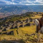
T’aqrachullo is located at kilometer 29 of the dirt road that begins in the town of Suyckutambo, in the district of the same name, province of Espinar, Cusco Region. The official entrance point to the archaeological site is the Totorani Bridge, spanning the river of the same name, which marks access to the plateau where more than 600 structures of the complex are distributed.
The site lies within the Tres Cañones Regional Conservation Area, a territory of great ecological and scenic value that includes the Apurímac, Virginniyoc, and Totorani canyons. This location makes it a destination with dual significance: archaeological and natural.
The province of Espinar, whose capital city is Yauri, serves as the main logistical hub for visiting the site. From Yauri, dirt roads lead toward Suyckutambo and the archaeological complex, while the city itself offers lodging, fuel stations, restaurants, and traveler services.
Route 1 — From Cusco: The Most Commonly Used Route
The route from Cusco is the most direct and the one used by most visitors. It covers 244 kilometers (152 miles) along a road that combines paved and gravel sections, with a final dirt-road segment that requires caution.
Step-by-Step from Cusco
- Section 1 — Cusco to Yauri (capital of Espinar): 199 km along Highway PE-3S heading south. The route passes through Combapata and Sicuani before climbing toward the Espinar highlands. The pavement is in good condition for most of the journey. Estimated travel time: 4 to 4.5 hours.
- Section 2 — Yauri to Suyckutambo: 35 km on a gravel road. Estimated travel time: 45 minutes. If you are driving your own vehicle, this is the place to refuel, as there are no gas stations beyond Yauri.
- Section 3 — Suyckutambo to Totorani Bridge (entrance to T’aqrachullo): 29 km on a dirt road. This is the most demanding part of the journey. The road may be in good condition during the dry season but can deteriorate significantly during the rainy season. Estimated travel time: 45 to 60 minutes depending on road conditions.
Route Summary from Cusco
- Total distance: 244 km (152 miles)
- Total estimated travel time: 5 hours 45 minutes to 6 hours
- Road type: paved road (199 km) + gravel road (35 km) + dirt road (29 km)
- Recommended vehicle: four-wheel drive (4×4), especially for the final section
- Best departure time: 4:30–5:00 AM in order to arrive at the site between 10:00 and 11:00 AM with ideal lighting conditions
Key Landmarks Along the Route
- Sicuani: the last major city before reaching Espinar. A good place for breakfast and refueling.
- Abra La Raya: a mountain pass at 4,335 meters (14,222 feet) above sea level on the route toward Puno. If your route takes you here, you have gone off course—T’aqrachullo lies west, not south.
- Yauri / Espinar: provincial capital with lodging, restaurants, gas stations, and the possibility of hiring a local guide.
- Suyckutambo: a small town and the last point with basic services before reaching the site.
- Totorani Bridge (km 29): the official entrance to the archaeological complex.
Route 2 — From Arequipa: The Colca Route
The route from Arequipa is longer in distance but offers the possibility of combining the visit with the Colca Canyon, one of the deepest canyons in the world, making it an attractive option for travelers with several days available.
Step-by-Step from Arequipa
- Section 1 — Arequipa to Chivay: 160 km along Highway PE-34A to the junction at Patahuasi, continuing toward Chivay through the Colca Canyon region. Estimated travel time: 3.5 hours.
- Section 2 — Chivay to Callalli and Sibayo: continuing along PE-34A across the high-Andean plateau. Estimated travel time: 1.5 hours.
- Section 3 — Sibayo to Suyckutambo: via gravel roads crossing the border between the Arequipa and Cusco regions. Estimated travel time: 1.5 hours.
- Section 4 — Suyckutambo to Totorani Bridge: 29 km of dirt road. Estimated travel time: 45–60 minutes.
Route Summary from Arequipa
- Total distance: approximately 370 km (230 miles)
- Total estimated travel time: 7.5 to 8 hours
- Advantage: allows travelers to combine the journey with a visit to Colca Canyon
- Recommendation: complete the route over two days, spending the night in Chivay or Sibayo
Route 3 — From Puno: Crossing the Altiplano
The route from Puno connects the Puno Altiplano with the province of Espinar through a highway that crosses some of the most open and isolated landscapes in the southern Andes. It is a route of remarkable beauty, but one that requires either a private vehicle or specially arranged transportation.
Step-by-Step from Puno
- Section 1 — Puno to Juliaca: 45 km via Highway PE-34. Estimated travel time: 45 minutes.
- Section 2 — Juliaca to Santa Lucía, Lagunillas, and Imata: continuing west along Highway PE-34A, crossing the Collao Plateau. Estimated travel time: 2.5 hours.
- Section 3 — Imata to Negromayo and Héctor Tejada: descending toward the Apurímac watershed. Estimated travel time: 1 hour.
- Section 4 — Héctor Tejada to Yauri: entering the province of Espinar. Estimated travel time: 1 hour.
- Section 5 — Yauri to Totorani Bridge: the same final route used from Cusco. Estimated travel time: 1.5 hours.
Route Summary from Puno
- Total distance: approximately 320 km (199 miles)
- Total estimated travel time: 7 to 7.5 hours
- Recommended vehicle: four-wheel drive (4×4)
- Recommendation: leave Puno very early in the morning or spend the night in Yauri before visiting the site
Route 4 — From Apurímac: The Alternative Route
This route is less frequently used but entirely viable for travelers coming from Abancay or Chalhuahuacho (the Las Bambas mining region). It offers dramatic scenery while crossing the western Andes toward Espinar.
Step-by-Step from Apurímac
- Section 1 — Chalhuahuacho to Abra Acopunco: via Highway PE-3Sw, climbing toward the mountain pass. Estimated travel time: 1.5 hours.
- Section 2 — Abra Acopunco to Santo Tomás: descending toward the capital of Chumbivilcas Province. Estimated travel time: 1 hour.
- Section 3 — Santo Tomás to Velille and Coporaque: along gravel roads crossing into Espinar Province. Estimated travel time: 2 hours.
- Section 4 — Coporaque to Suyckutambo and Totorani Bridge: estimated travel time: 1.5 hours.
Route Summary from Apurímac
- Total distance: approximately 200 km (124 miles) from Chalhuahuacho
- Total estimated travel time: 6 to 6.5 hours
- Ideal for: travelers coming from southern Cusco or the Apurímac mining corridor
Transportation Options: Private Vehicle, Bus, or Tour?
Option 1 — Private or Rental Vehicle
This is the option that offers the most freedom and is the most highly recommended way to visit T’aqrachullo. It allows travelers to depart whenever needed, stop at scenic viewpoints along the route, and adjust the amount of time spent at the site according to personal interests.
- Recommended vehicle type: four-wheel drive (4×4) for the dirt-road section. During the dry season, a vehicle with good ground clearance may be sufficient, but a 4×4 provides additional safety and confidence.
- Vehicle rental in Cusco: from approximately 150 soles per day for standard vehicles to 300–500 soles per day for 4×4 models. Verify that the rental agreement allows driving on unpaved roads.
- Fuel: fill the tank in Cusco and refuel again in Yauri. There are no gas stations between Suyckutambo and the archaeological site.
- GPS and offline maps: mobile data coverage is extremely limited between Yauri and the site. Download local maps using Google Maps or Maps.me before departing.
Option 2 — Bus from Cusco to Yauri + Local Taxi
For travelers without an international driver’s license or those who prefer not to rent a vehicle, this combination is generally the most practical solution.
- Cusco–Yauri bus: departures from the Tupac Amaru Bus Terminal in Cusco. Several companies operate this route (availability should be verified at the terminal). Travel time: 4.5–5 hours. Approximate fare: 25–40 soles.
- From Yauri: hire a local taxi or moto-taxi for the Yauri–Suyckutambo–Totorani Bridge section. Approximate negotiated cost: 80–120 soles round trip, including waiting time at the site (2–3 hours). Agree on the fare, waiting time, and pickup location before departure.
- Important consideration: local drivers from Yauri know the route well. Specifically ask for drivers who have previously transported visitors to the site to ensure they are familiar with the road leading to Totorani Bridge.
Option 3 — Organized Tour from Cusco
Since T’aqrachullo only recently opened to tourism, relatively few agencies currently offer regular departures to the site. However, the number continues to grow steadily. Organized tours generally include transportation in a 4×4 vehicle, a certified guide, lunch, and in some cases an overnight stay in Yauri.
- Advantage: no logistical concerns for the traveler. The guide provides historical and archaeological context that greatly enriches the visit.
- Approximate cost: 200–400 soles per person for a group tour.
- How to find operators: inquire at travel agencies in Cusco’s Historic Center or search specifically for “T’aqrachullo Tour Cusco“.
- Recommendation: verify that the operator has experience with the route and that the vehicle provided is truly a 4×4.
Where to Stay Near T’aqrachullo
Since the journey from Cusco takes nearly six hours, spending the night in Yauri before visiting is the most practical strategy. It allows travelers to arrive at the site early in the morning when lighting conditions are best for photography and the freezing early-morning temperatures have eased enough for comfortable exploration.
Yauri (Capital of Espinar)
Yauri is the most developed lodging option near T’aqrachullo, offering a variety of hotels and guesthouses that accommodate different budgets. The city has restaurants, markets, ATMs, and complete basic services.
- Mid-range hotels: 80–150 soles per night. Look for accommodations with heating, given the cold temperatures of the high plateau, which can drop below 0°C (32°F) at night.
- Budget accommodations: starting at 40–60 soles per night in basic guesthouses.
- Distance to T’aqrachullo: approximately 1.5 hours by road from Yauri.
Suyckutambo
The town of Suyckutambo, located closer to the archaeological site, offers only very basic lodging options—typically family homes that host travelers—for those who wish to stay as close as possible to the complex. There are no formal hotels. Travelers should inquire with the district municipality or local guides regarding availability.
Practical Recommendations for Accessing the Site
- Best season for access: May through October (dry season). During the rainy season (November through March), the final dirt-road section may become impassable even for 4×4 vehicles. Always verify road conditions before departure.
- Fuel: fill the tank completely in Cusco or Sicuani. Refuel again in Yauri before continuing to the final section.
- Mobile signal: virtually nonexistent between Suyckutambo and the site. Download offline maps, save contact numbers in Yauri, and carry a printed or written itinerary.
- Opening hours: the site generally operates from 8:00 AM to 4:00 PM. Plan to arrive before 10:00 AM to allow at least 3–4 hours for a comfortable visit before closing.
- Clothing: even if you leave Cusco under pleasant weather conditions, the Espinar highlands may experience daytime temperatures between 5°C and 10°C (41°F–50°F) and below-freezing temperatures at night. Always carry a waterproof jacket and gloves, even if the sky is clear when you depart.
- Altitude: T’aqrachullo sits at more than 4,000 meters (13,123 feet) above sea level. If arriving directly from Cusco without proper acclimatization, symptoms of altitude sickness may occur. At least 48 hours of acclimatization in Cusco (3,400 m / 11,155 ft) is recommended before undertaking this journey.
- Basic first-aid kit: bring ibuprofen, altitude-sickness medication, oral rehydration salts, and bandages. The nearest medical facilities are located a considerable distance from the site.
- Prior confirmation: before departing, confirm access conditions with the Cusco Regional Office of Culture or the District Municipality of Suyckutambo. Because the site is newly open to tourism, conditions may change.
Summary Table of Access Routes
🚗 How to Reach T’aqrachullo from the Main Cities of Southern Peru
🟡 Moderate: paved highway for most of the route.
🟠 Moderate–High: long journey with rural sections and gravel roads.
🔴 High: mountain routes with challenging access and more demanding logistics.
Frequently Asked Questions About Getting to T’aqrachullo
How long does it take to get to T’aqrachullo from Cusco?
Approximately 5 hours and 45 minutes under normal conditions: 4 to 4.5 hours on paved roads to Yauri, 45 minutes on gravel roads to Suyckutambo, and between 45 and 60 minutes on dirt roads to Totorani Bridge, the official entrance to the archaeological site.
Is a 4×4 vehicle necessary to reach T’aqrachullo?
A four-wheel-drive vehicle is strongly recommended for the dirt-road section (29 km from Suyckutambo), especially during the rainy season. In the dry season, a vehicle with good ground clearance may be sufficient, but four-wheel drive provides greater safety and peace of mind on uneven terrain.
Is there direct public transportation to T’aqrachullo?
No direct public transportation service currently reaches the archaeological site. Buses operate between Cusco and Yauri (departing from the Tupac Amaru Bus Terminal, approximately 25–40 soles). From Yauri, travelers must hire a local taxi or moto-taxi for the final stretch to Totorani Bridge (approximately 80–120 soles round trip including waiting time).
Where should I stay near T’aqrachullo?
Yauri, the capital of Espinar Province, is the closest lodging hub with hotel infrastructure available, located approximately 1.5 hours from the site. Spending the night there before your visit is highly recommended so you can depart early and arrive at the archaeological complex under the best morning light.
What time of year is it easiest to reach T’aqrachullo?
Between May and October, during the dry season. The final dirt-road section is the critical point of the route: during the rainy season (November through March), it can become impassable even for 4×4 vehicles. Always verify road conditions before departing, especially during transitional months such as April and November.
Can T’aqrachullo be visited as a day trip from Cusco?
Technically yes. Travelers can leave Cusco between 4:30 and 5:00 AM, arrive at the site between 10:00 and 11:00 AM, explore the archaeological complex for 3–4 hours, and return to Cusco late in the afternoon. However, this results in a very long and tiring day. The ideal option is to spend the night in Yauri in order to enjoy the site without rushing and without the stress of a long return journey.
Conclusion: The Distance Is Part of the Journey
Getting to T’aqrachullo is not difficult, but it is not immediate either. And far from being a disadvantage, that is precisely what protects the site from the overtourism that already affects many of the region’s most famous archaeological destinations.
Every kilometer of dirt road between Suyckutambo and Totorani Bridge serves as a natural filter, ensuring that when you finally arrive, you will be able to walk among more than 300 restored structures with the freedom and silence that Inca archaeology deserves. No lines. No assigned entry times. No hundreds of tourists competing for the same photo angle.
Plan your route carefully, bring the appropriate vehicle, leave early, and spend the night in Yauri if possible. T’aqrachullo will take care of the rest.